(The English version is below)
Bahasa Malaysia
Sejarah panjang Sungai Klang
FAISAL SURANI
05 September 2015 12:41 AM
ALIRAN sungai sepanjang 120 kilometer (km) mengunjur dari tengah-tengah bandar raya Kuala Lumpur sehinggalah ke Pelabuhan Klang menjadikan Sungai Klang antara sungai yang mempunyai peranan terpenting dalam aspek kehidupan masyarakat di Selangor.
Peranan itu sebenarnya telahpun bermula sejak beribu tahun lamanya apabila bukti sejarah menunjukkan wujud penempatan manusia di sepanjang sungai itu sejak 4,500 tahun lampau.
Penemuan secara tidak sengaja artifak-artifak purba di sekitar bandar Klang dan berdekatan Sungai Klang menunjukkan telah wujud penempatan yang menjadikan sungai sebagai nadi kehidupan ketika itu.
Menurut Pengkaji Sejarah Selangor, Faisal Surani, Sungai Klang memisahkan bandar Klang kepada dua bahagian iaitu Klang Utara dan Klang Selatan. Hasil utama di sekitar lembangan sungai ini adalah bijih timah yang diusahakan sejak awal abad ke-14 sehingga ke abad 20.
“Malah pada abad ke-19, Sungai Klang merupakan kawasan perlombongan utama bijih timah dengan pengeluaran sebanyak 2,000 pikul setahun ketika itu. Orang keturunan Mandailing yang banyak mengusahakan bijih timah di sini kerana mereka memang amat terkenal sebagai pelombong yang mahir,” katanya kepada S2.
Faisal berkata, peranan Sungai Klang sudah wujud begitu lama sehingga ia menjadi pusat penempatan, pengangkutan dan perhubungan kepada manusia daripada generasi ke generasi seterusnya. Sehingga hari ini sungai itu masih lagi mempunyai kepentingan kepada masyarakat Selangor.
Katanya, peredaran zaman telah menyaksikan banyak perubahan berlaku terhadap Sungai Klang terutama bentuk geografinya. Menurutnya, aliran Sungai Klang sudah tidak sama kerana berubah sejak 500 tahun lalu.
“Contohnya di dalam bandar raya Kuala Lumpur sendiri, aliran Sungai Klang yang ada pada hari ini sebenarnya sudah diubah mungkin pada zaman Perang Klang dan zaman penjajahan British dahulu ekoran aktiviti perlombongan,” katanya.
Menurutnya, ada antara jalan-jalan di dalam bandar raya Kuala Lumpur dahulunya merupakan aliran dari Sungai Klang itu sendiri.
Tambahnya, orang-orang berketurunan Mandailing yang banyak datang ke Kuala Lumpur ketika itu untuk melakukan aktiviti melombong bijih timah di sekitar Jalan Masjid India dan kawasan berdekatan. Sementara orang berketurunan Minangkabau pula lebih ramai mendiami di tepi-tepi Sungai Klang sehingga ke hari ini.
Katanya, itu adalah kawasan asal bagaimana Kuala Lumpur terbentuk. Lebih menarik, kawasan Dataran Merdeka juga merupakan sebuah paya yang telah ditambak oleh pihak British suatu masa dahulu.
Faisal berkata, banyak kampung-kampung tradisi yang wujud di sekitar Sungai Klang seperti di Kapar dan Pulau Indah.
Lebih menarik, katanya, berdekatan dengan Sungai Klang iaitu di sekitar Pandamaran juga terdapat satu landasan kapal terbang yang dibina ketika zaman penjajahan British namun ramai yang tidak mengetahui mengenai perkara itu.
“Kawasan lapangan terbang di situ kini sudah menjadi sekolah dan padang. Selepas Jepun menduduki Tanah Melayu, lapangan terbang itu masih wujud namun kini ia sudah dijadikan jalan raya,” katanya.
Menyentuh mengenai pelabuhan pula, Faisal berkata, sebelum kedatangan British, Pelabuhan Klang dikenali sebagai Kuala Klang. Berdasarkan sejarah lisan di situ, muara Sungai Klang pula dipanggil sebagai Pasang Api dalam kalangan penduduk tempatan dan Orang Asli di sekitar kawasan itu dahulu.
“Ini kerana semasa pemerintahan Kerajaan Melayu Melaka, Penghulu Tun Perak telah mengarahkan api dipasang di bahagian muara Sungai Klang pada waktu malam sebagai langkah keselamatan dari ancaman lanun dan sebagai panduan kepada perahu serta kapal keluar masuk pada waktu malam,” katanya.
Katanya, Kuala Klang merupakan sebuah perkampungan kecil yang didiami oleh nelayan dan petani sementara Sungai Klang pula menjadi penghubung antara Kuala Klang dengan Pengkalan Batu, bandar Klang serta Kuala Lumpur.
“Pada masa itu, Pengkalan Batu merupakan pelabuhan utama dan menjadi pusat perdagangan termasuklah pemunggahan hasil bijih timah di Bandar Klang. Namun, fungsi pelabuhan di situ mulai merosot setelah British membina jambatan Belfield yang menghubungkan Klang Utara dan Klang Selatan.
“Pelabuhan yang baharu di Kuala Klang kemudian dicadangkan oleh Sir Frank Swettenham pada 1893 tetapi hanya dibina pada 1900 setelah landasan kereta api dari bandar Klang ke Kuala Klang dibina pada 1889,” katanya.
Beliau berkata, Pelabuhan Swettenham kemudian dibuka secara rasmi pada 15 September 1901. Pelabuhan itu ditukar nama kepada Pelabuhan Klang selepas Tanah Melayu mencapai kemerdekaan pada 31 Ogos 1957.
Katanya, sehingga kini peranan Sungai Klang kepada masyarakat malah flora dan fauna di sekitarnya tidak pernah putus. Sejarah panjang Sungai Klang membuktikan betapa aliran sungai itu amat penting kepada manusia sejak berabad lamanya.
Source:
http://www.utusan.com.my/rencana/utama/sejarah-panjang-sungai-klang-1.131773#ixzz5QD45M8pA
English
Rich Waters
By Emily Ding - January 8, 2017 @ 2:06pm
The Klang River, now much neglected, was once a source of Malaya’s wealth, writes Emily Ding
IF you climb to the peak of Bukit Tabur, you’ll be able to see the familiar skyline of Kuala Lumpur and the Klang Gates Dam, which holds Malaysia’s first water reservoir. Beyond it, somewhere deep in the tropical forest of the Titiwangsa mountain range that forms the backbone of Peninsula Malaysia, is where the Klang River begins.
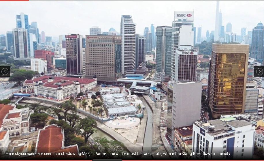
Most photographs you’ll see of the Klang River shows it passing right through the centre of our capital city, where it collides with the Gombak River at the steps of Masjid Jamek, one of Malaysia’s oldest mosques. It’s fitting as this is where, it’s believed, Kuala Lumpur — “muddy confluence” —got its name. The Klang River was once the source of wealth for the capital city but after decades of industrialisation, the river has faded under the glitz of the skyscrapers that dot the city.
Kickstarted in 2011, overseen by the Performance Management & Delivery Unit (Pemandu) and involving the cooperation of Federal and State ministries and agencies, the River of Life project (ROL) aims to clean up the river waters and beautify the riverbank, in hopes that a rejuvenated river will attract the development of public, commercial and residential spaces, and spark the beginning of a long-lasting revival.
RIVER ROOTS
It’s impossible to talk about the history of Kuala Lumpur without talking about the history of Klang, the old capital of Selangor before it moved to Kuala Lumpur. Klang has been settled by humans since ancient times, evidenced by the discovery of artefacts dating back to the Bronze Age, circa 300 B.C. Even as early as 1405, Chinese explorer Admiral Cheng Ho made the first of his seven “treasure voyages” in and around the South China Sea and the Indian Ocean, he was guided by maritime charts that already had the Klang River marked out and named.
By the 1820s, the Klang River basin had already become known as an important centre of tin mining. More than 20 villages with an estimated total population of 1,500, made up mainly of ethnic Malays from Sumatra, had cropped up along the river to search for tin. But it wasn’t until new mining techniques and machinery, imported along with Chinese labourers was it possible to reach deposits at much greater depths that the industry took a leap forward. It was around this time that the story of Kuala Lumpur began.
In 1857, the chief of the Klang Valley, Raja Abdullah, sent a party of miners to the confluence of the Klang and Gombak rivers to prospect for tin in the valley’s upper reaches. All the men would perish eventually from malaria but the mines were open for business — at Ampang, Pudu, Batu — and soon, there was a steady and profitable trade going.
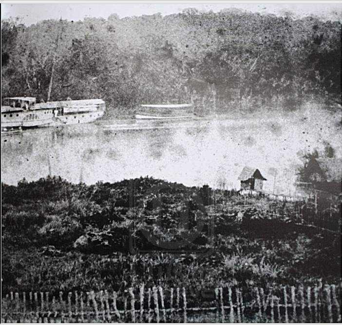
At this time, the Klang River was the only effective means of transportation. The historian J.M. Gullick described it as “the only highway through the jungle”. Boats would make the four-day transit to and from the town of Klang to the confluence of the Klang and Gombak rivers to load and offload their cargoes, since it was the furthest point upriver through which heavy boats could traverse. As ancillary trade grew, Kuala Lumpur became a trade centre serving the outlying mines.
Even the devastating effects of the Selangor Civil War of 1867-1874, which destroyed the mines, didn’t dim Kuala Lumpur’s prospects. Under the watch of Yap Ah Loy, the-then village kapitan, the town was rebuilt. Just after Selangor came under British colonial rule in 1874, the Resident General of the Federated Malay States, Frank Swettenham, visited Kuala Lumpur and declared it “the best mining village I have seen”, and in just a few years, Kuala Lumpur would overtake Klang to become the new Selangor capital. Similarly, it would survive the extensive fire in early 1881 and the flood later that same year, which destroyed numerous buildings, including Yap Ah Loy’s house. But some places persisted despite the odds stacked against them, through the sheer will of its people.
By the 1890s, Kuala Lumpur had grown into a sizeable town with a population of about 20,000. It would continue to grow decade after decade even after the tin rush ended, with an estimated population today of 1.7 million, spurred on by the mass production of rubber and palm oil, and then the rise of the manufacturing industries. Even in the early days, this boom of population and growth, coupled with natural disasters and disease, contributed to sanitary and pollution problems and neglect. Eventually, this would all take a toll on the river.
CHANGING TIDES
There’s a certain irony in the story of the Klang River. The river had created the city but as the city developed, it outgrew the river. According to George Peet, a former editor of The Straits Times, who visited Kuala Lumpur in the 1930s, the death knell had sounded when the Kuala Lumpur-Klang railway line was completed in 1886. As the population and the demands of industry grew, the four-hour boat journey was no longer an efficient means of transportation. In the first of the modifications that would be made to the river in service of human needs, one bend of the river was straightened to provide space for railway use. As road transportation arrived on a larger scale, the Klang River fell into further disuse and neglect.
Today, the Klang River is mainly used to supply water, though it’s not the major water source, since most of the potable water for Klang Valley is supplied from the dams in the Selangor River basin. According to the Global Environmental Centre, the Klang River and its tributaries supply 1,128.4 million litres per day for Selangor and Kuala Lumpur. The Klang Gates Dam reservoir alone, which has a capacity of more than 25 million litres, routes water directly to a water treatment plant in Bukit Nanas and produces 145 million litres of treated water each day.
The Klang River is too polluted to be of much practical or recreational use. According to a government agency’s report, the water quality at the upper reaches of the Klang River basin is Class I or II but the quality steadily worsens to Class III, IV or V — meaning it’s not suitable for body contact — as the river wends downstream due to effluents from sewage treatment plants, commercial and residential centres, industries and workshops, food industries, restaurants, wet markets and squatters.
FLOOD CENTRAL
From the early days, two major floods contributed significantly to what the Klang River looks like today. In 1926, a deluge —“the mother and father of all floods”, as Gullick described it — submerged the town to a depth of 900m. Then there was the massive flood of 1971, which lasted five days as a result of torrential monsoon rains and killed 32 people. As a result of these disasters, the Klang River that was drastically straightened, deepened and widened, to mitigate flood occurrences. The river began to resemble a canal (or a big drain), its banks transformed from mud and natural vegetation to slabs of concrete.
Still, the problem persisted, with major floods occurring every decade. In another effort to mitigate the floods, in 2003 the federal government built the 9.7km-long submerged Stormwater Management and Road Tunnel (SMART Tunnel) that could carry traffic as well as stormwater runoff, intended to solve the problem of flash floods in the Jalan Melayu-Masjid India area of Kuala Lumpur and traffic jams along Jalan Sungai Besi and the Lok Yew flyover at Pudu.
But things have only gotten worse. According to a government agency, flooding problems are increasing from year to year and they are no longer limited to the rainy season. Numerous possible contributing causes have been highlighted, including increasing siltation due to heavy construction along the riverbanks and unsustainable rubbish disposal practices.
BUILDING FUTURES
Still, we build. The still rapidly growing city and its burgeoning population demand it. In further alienation of its original, natural features, the Klang River was transformed into a transportation corridor in the late 1990s. A modern public transportation system — the Ampang Elevated Highway and Light Railway Transit — was constructed in a parallel line above the river, straightening and concretising it further.
The river cleaning phase will continue to be carried out along a 110km stretch along the Klang River, covering the municipal districts of Selayang, Ampang Jaya and Kuala Lumpur. The aim is to rehabilitate the water from its current Class III-V water quality to Class IIB by 2020, so as to be suitable for body contact and recreation. Other measures include building new water treatment plants, upgrading existing sewage facilities and drainage systems, and dealing with industrial discharge and general rubbish disposal in a sustainable manner. With the Klang River’s water quality improved, both locals and visitors to Kuala Lumpur would be able to swim and fish as they did in the old days, even partake in water sports like canoeing.
As for the riverbank, beautification works are focused along the Klang River’s most visible stretch: The 10.7 km along the central section, where it flows just below the steps of Masjid Jamek. It’s a symbolic move given this spot is Kuala Lumpur’s birthplace and a well-known landmark.
But Rome wasn’t built in a day and our cities are often what our imaginations make it. If all goes according to plan, the Klang River will transform from divider to connector: Between the diverse inhabitants of the city, between nature and concrete, and between heritage and modernity. Just imagine the river as an integral part of the city so that when one thinks of Kuala Lumpur, one can’t help but think of the Klang River — the same way one can’t help but think of the Thames when they think of London or the Seine, when they think of Paris. Just imagine.
Source:
https://www.nst.com.my/news/2017/01/202751/rich-waters
Rich Waters
By Emily Ding - January 8, 2017 @ 2:06pm
The Klang River, now much neglected, was once a source of Malaya’s wealth, writes Emily Ding
IF you climb to the peak of Bukit Tabur, you’ll be able to see the familiar skyline of Kuala Lumpur and the Klang Gates Dam, which holds Malaysia’s first water reservoir. Beyond it, somewhere deep in the tropical forest of the Titiwangsa mountain range that forms the backbone of Peninsula Malaysia, is where the Klang River begins.
Most photographs you’ll see of the Klang River shows it passing right through the centre of our capital city, where it collides with the Gombak River at the steps of Masjid Jamek, one of Malaysia’s oldest mosques. It’s fitting as this is where, it’s believed, Kuala Lumpur — “muddy confluence” —got its name. The Klang River was once the source of wealth for the capital city but after decades of industrialisation, the river has faded under the glitz of the skyscrapers that dot the city.
Kickstarted in 2011, overseen by the Performance Management & Delivery Unit (Pemandu) and involving the cooperation of Federal and State ministries and agencies, the River of Life project (ROL) aims to clean up the river waters and beautify the riverbank, in hopes that a rejuvenated river will attract the development of public, commercial and residential spaces, and spark the beginning of a long-lasting revival.
RIVER ROOTS
It’s impossible to talk about the history of Kuala Lumpur without talking about the history of Klang, the old capital of Selangor before it moved to Kuala Lumpur. Klang has been settled by humans since ancient times, evidenced by the discovery of artefacts dating back to the Bronze Age, circa 300 B.C. Even as early as 1405, Chinese explorer Admiral Cheng Ho made the first of his seven “treasure voyages” in and around the South China Sea and the Indian Ocean, he was guided by maritime charts that already had the Klang River marked out and named.
By the 1820s, the Klang River basin had already become known as an important centre of tin mining. More than 20 villages with an estimated total population of 1,500, made up mainly of ethnic Malays from Sumatra, had cropped up along the river to search for tin. But it wasn’t until new mining techniques and machinery, imported along with Chinese labourers was it possible to reach deposits at much greater depths that the industry took a leap forward. It was around this time that the story of Kuala Lumpur began.
In 1857, the chief of the Klang Valley, Raja Abdullah, sent a party of miners to the confluence of the Klang and Gombak rivers to prospect for tin in the valley’s upper reaches. All the men would perish eventually from malaria but the mines were open for business — at Ampang, Pudu, Batu — and soon, there was a steady and profitable trade going.
At this time, the Klang River was the only effective means of transportation. The historian J.M. Gullick described it as “the only highway through the jungle”. Boats would make the four-day transit to and from the town of Klang to the confluence of the Klang and Gombak rivers to load and offload their cargoes, since it was the furthest point upriver through which heavy boats could traverse. As ancillary trade grew, Kuala Lumpur became a trade centre serving the outlying mines.
Even the devastating effects of the Selangor Civil War of 1867-1874, which destroyed the mines, didn’t dim Kuala Lumpur’s prospects. Under the watch of Yap Ah Loy, the-then village kapitan, the town was rebuilt. Just after Selangor came under British colonial rule in 1874, the Resident General of the Federated Malay States, Frank Swettenham, visited Kuala Lumpur and declared it “the best mining village I have seen”, and in just a few years, Kuala Lumpur would overtake Klang to become the new Selangor capital. Similarly, it would survive the extensive fire in early 1881 and the flood later that same year, which destroyed numerous buildings, including Yap Ah Loy’s house. But some places persisted despite the odds stacked against them, through the sheer will of its people.
By the 1890s, Kuala Lumpur had grown into a sizeable town with a population of about 20,000. It would continue to grow decade after decade even after the tin rush ended, with an estimated population today of 1.7 million, spurred on by the mass production of rubber and palm oil, and then the rise of the manufacturing industries. Even in the early days, this boom of population and growth, coupled with natural disasters and disease, contributed to sanitary and pollution problems and neglect. Eventually, this would all take a toll on the river.
CHANGING TIDES
There’s a certain irony in the story of the Klang River. The river had created the city but as the city developed, it outgrew the river. According to George Peet, a former editor of The Straits Times, who visited Kuala Lumpur in the 1930s, the death knell had sounded when the Kuala Lumpur-Klang railway line was completed in 1886. As the population and the demands of industry grew, the four-hour boat journey was no longer an efficient means of transportation. In the first of the modifications that would be made to the river in service of human needs, one bend of the river was straightened to provide space for railway use. As road transportation arrived on a larger scale, the Klang River fell into further disuse and neglect.
Today, the Klang River is mainly used to supply water, though it’s not the major water source, since most of the potable water for Klang Valley is supplied from the dams in the Selangor River basin. According to the Global Environmental Centre, the Klang River and its tributaries supply 1,128.4 million litres per day for Selangor and Kuala Lumpur. The Klang Gates Dam reservoir alone, which has a capacity of more than 25 million litres, routes water directly to a water treatment plant in Bukit Nanas and produces 145 million litres of treated water each day.
The Klang River is too polluted to be of much practical or recreational use. According to a government agency’s report, the water quality at the upper reaches of the Klang River basin is Class I or II but the quality steadily worsens to Class III, IV or V — meaning it’s not suitable for body contact — as the river wends downstream due to effluents from sewage treatment plants, commercial and residential centres, industries and workshops, food industries, restaurants, wet markets and squatters.
FLOOD CENTRAL
From the early days, two major floods contributed significantly to what the Klang River looks like today. In 1926, a deluge —“the mother and father of all floods”, as Gullick described it — submerged the town to a depth of 900m. Then there was the massive flood of 1971, which lasted five days as a result of torrential monsoon rains and killed 32 people. As a result of these disasters, the Klang River that was drastically straightened, deepened and widened, to mitigate flood occurrences. The river began to resemble a canal (or a big drain), its banks transformed from mud and natural vegetation to slabs of concrete.
Still, the problem persisted, with major floods occurring every decade. In another effort to mitigate the floods, in 2003 the federal government built the 9.7km-long submerged Stormwater Management and Road Tunnel (SMART Tunnel) that could carry traffic as well as stormwater runoff, intended to solve the problem of flash floods in the Jalan Melayu-Masjid India area of Kuala Lumpur and traffic jams along Jalan Sungai Besi and the Lok Yew flyover at Pudu.
But things have only gotten worse. According to a government agency, flooding problems are increasing from year to year and they are no longer limited to the rainy season. Numerous possible contributing causes have been highlighted, including increasing siltation due to heavy construction along the riverbanks and unsustainable rubbish disposal practices.
BUILDING FUTURES
Still, we build. The still rapidly growing city and its burgeoning population demand it. In further alienation of its original, natural features, the Klang River was transformed into a transportation corridor in the late 1990s. A modern public transportation system — the Ampang Elevated Highway and Light Railway Transit — was constructed in a parallel line above the river, straightening and concretising it further.
The river cleaning phase will continue to be carried out along a 110km stretch along the Klang River, covering the municipal districts of Selayang, Ampang Jaya and Kuala Lumpur. The aim is to rehabilitate the water from its current Class III-V water quality to Class IIB by 2020, so as to be suitable for body contact and recreation. Other measures include building new water treatment plants, upgrading existing sewage facilities and drainage systems, and dealing with industrial discharge and general rubbish disposal in a sustainable manner. With the Klang River’s water quality improved, both locals and visitors to Kuala Lumpur would be able to swim and fish as they did in the old days, even partake in water sports like canoeing.
As for the riverbank, beautification works are focused along the Klang River’s most visible stretch: The 10.7 km along the central section, where it flows just below the steps of Masjid Jamek. It’s a symbolic move given this spot is Kuala Lumpur’s birthplace and a well-known landmark.
But Rome wasn’t built in a day and our cities are often what our imaginations make it. If all goes according to plan, the Klang River will transform from divider to connector: Between the diverse inhabitants of the city, between nature and concrete, and between heritage and modernity. Just imagine the river as an integral part of the city so that when one thinks of Kuala Lumpur, one can’t help but think of the Klang River — the same way one can’t help but think of the Thames when they think of London or the Seine, when they think of Paris. Just imagine.
Source:
https://www.nst.com.my/news/2017/01/202751/rich-waters